
Sandwip-Urir Char-Noakhali cross dam for long-term food security
 For all latest news, follow The Daily Star's Google News channel.
 Bangladesh with a population of 150 million and having only 91,500 sq km of land under cultivation is in a critical state so far as food security is concerned. Environmentally it is also in a crucial situation with less than 15 percent forest cover (preferable 25 percent). Available agricultural lands are fast depleting as: (i) about 100 sq km of agricultural land is eroded by rivers each year; and (ii) about another 1300 sq km is going out from agricultural to non-agricultural uses each year. Population increase of about 2 percent per year and simultaneous reduction of cultivable land are making the situation more and more precarious day by day. Increase of cultivable lands by reclamation from Meghna Estuary is one of the viable alternatives for enhancing individual and national food security as well as improving natural environment.
The natural process of accretion is giving rise to new chars along major portion of the 710km Bangladesh coast. The rate of natural accretion in the Noakhali region is about 90 ha per year since recent past and the same rate can be expected to continue in the coming years. Lands reclaimed (upto 1985) by Meghna -1, Meghna -2 and Muhuri cross dams were 300 sq. km, 600 sq. km and 500 sq. km respectively. Meghna cross dams have integrated Ramgati Island with Noakhali mainland. The landmass of Noakhali District has already exceeded 3600 sq km whereas the landmasses of neighbouring districts of Feni and Lakshmipur are 928 sq km and 1456 sq km respectively.
Land Reclamation Project (LRP) observed that the Lower Meghna River branch was already shifting to its present course into the Shahbazpur Channel when the Meghna cross dams were being constructed. Relevant studies, upland discharges and tidal flow distributions between different channels as well as on-going southward extension of Noakhali coast support the long term trend of shifting of Lower Meghna from eastern to western side. The trend signifies that eastern Meghna channels will die naturally in the long run, even without any external intervention.
Almost 2.4 billion tons of sediment passes to the Bay of Bengal each year through the Meghna Estuary. Holding of the passing sediments will give rise to about 200 sq km of land each year. Natural processes of accretion are slow and the outcomes are often fragile. It is neither technically impossible nor economically prohibitive to arrest a considerable portion of passing sediments for reclamation/ development of new lands. With external interventions, it is possible to sustain the gains and develop vast new landmasses at an accelerated rate.
LRP's study (1987) on the Sandwip-Urir Char-Noakhali Cross Dam found that the cross dam will give rise to about 18,000 ha new land in near future and another 18,000 ha within 30 years, directly benefiting more than 180,000 people. Evaluation of impacts by mathematical model confirmed that the dam would have only local effects on the water levels and tidal currents. At some distance from the dam, the changes in tidal volumes appeared to be limited to a few percent only. The study did not anticipate any negative effects on navigation at any place.
Morphological evaluation of the study indicated no or negligible impact on the erosion of Hatiya, Bhola, other off-shore islands and coasts of Noakhali mainland; as these processes were and would continue to be governed by the overall morphological processes in the Lower Meghna Estuary (the Cross Dam will have insignificant impact on the total morphological processes of the region). The Cross Dam was not going to affect the Chittagong Port in any way; as flow and sediment regime, tidal propagation etc. of the Karnaphuli River mainly depend on up-river discharges and tide levels of the confluence. Similarly, the study did not find any adverse impact on natural environment like forests or fisheries of the region.
'BWDB Task Force Report (2003)' as well as Mater Plan (1998) and Development Plan (1998) of Meghna Estuary Study (MES) recommended construction of the Sandwip-Urir Char-Noakhali Cross Dam as a priority project. The Task Force estimated reclamation of about 18,000 ha of lands (above + 2.2 mPwD) in 15 years and another 30,000 ha within next 15 years. Implementation of the Cross Dam is commensurate with all the related national policies and plans.
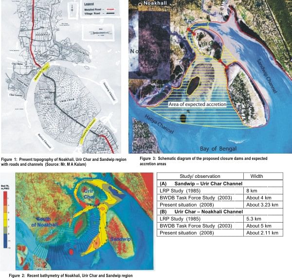
The channels between Sandwip and Noakhali are gradually being silted up and shrinking in width as a continuous natural process. The present ground levels (above mean sea level) of Urir Char Island are between 4 and 5 m whereas those of Noakhali coast varies between 3 and 4 m. Present topography of the region and channel bathymetry are shown in Figure 1 and Figure 2 respectively. MES's (1998) expectation of natural building up of a connection between Sandwip and Noakhali mainland, without external intervention, is coming out as a reality. The following table shows the gradual reduction in width of the channels: -
The major tasks of the Sandwip-Urir Char-Noakhali Cross Dam Project have now virtually come down to closing of channels between Sandwip-Urir Char and Urir Char-Noakhali only. Figure 3 schematically shows the locations of closure dams and expected areas of accretion. The proposed closure dam sites are located at meeting places of tides coming from opposite sides. Considerable portions of the channel of the sites dry up (and water depth become very low at other places) during winter low tides. Estimated cost of the Cross Dam (2 closure dams and other ancillary minor works) comes to around Taka 700 million only. The Cross Dam is going to give rise to 360 sq. km or more lands within 30 years and integrate Sandwip, Urir Char etc. with Noakhali mainland by a continuous land mass.
The Cross Dam is neither going to block nor obstruct any upland discharge/channel flow of the region. Muhuri River, Little Feni River, Bamni River and other local channels will have their own free passages for discharging into Sandwip or Hatiya channels. Present water logging of Noakhali district will go on increasing due to southward extension of coast as a result of natural accretion (even without the Cross Dam) unless mitigatory measures are taken.
The Fisheries Department has declared the following zones as hilsha sanctuaries:- (i) 100 km of the Lower Meghna Estuary from Shatnol (Chandpur) to Char Alexander (Lakshmipur), (ii) 90 km of the Shahbazpur River from Madanpur/Char Ilisha (Bhola) to Char Pear (Bhola) and (iii) 100 km of the Tetulia River from Bheduria (Bhola) to Char Rustom (Patuakhali). The proposed cross dam will not affect the hilsha sanctuaries or any migratory birds in any way.
Some of the pertinent facts of the Sandwip-Urir Char-Noakhali Cross Dam are:
* Available BWDB expertise and experiences are sufficient to implement the project. Estimated cost of Taka 70 crore is manageable even with own resources of the government.
* Closure dam sites are located at meeting places of tides coming from opposite directions. Considerable portion of the channel drys up (and water depth becomes very low at remaining portion) during winter low tides at these places.
* The Cross Dam would give rise to about 360 sq. km of land benefiting 1,80,000 people directly and the whole nation indirectly. Newly gained lands could be used for agriculture, homestead, forestry etc. This will enable production of food grains as well as create job opportunity helping in development of individual and national food security. New afforestations will increase availability of forest products, create new jobs and improve natural environment.
* The continuous land strip with its peripheral mangrove belt will provide protection to lives and properties against cyclones and tidal surges.
* Sandwip and Urir Char would be integrated with Noakhali mainland and direct road communication would be possible. This will also enable construction of over-land electricity, telecommunication and gas transmission systems at a fraction of presently required under-sea construction costs.
* No major consequential negative impact is anticipated. The Cross Dam is neither going to block nor obstruct any upland discharge/drainage channel.
Shahidur Rahman Khan, M.Engg, P.Eng. is a Water Resources Engineer/ Coastal Morphologist
The above is a compilation from studies of different sources, collected over a period of time. As such, some of the figures might be indicative. Expressed views are writer's personal opinions.


Comments