
South Talpatti-New Moore dispute
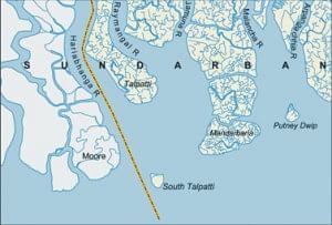
Figure: Location of South Talpatti in southwestern Bangladesh (adapted from Banglapedia)
 For all latest news, follow The Daily Star's Google News channel.
 AFTER 28 years our big neighbour India extended her hands in discussing maritime boundary inclusive of the South Talpatti vs. New Moore island issue. But the outcome was only 'diplomatically successful', in actuality it was just a failure.
Bangladesh is encircled by India on three sides. We have anthropologically the same origin, have the state languages (Bangla and Hindi) derived from the same Sanskrit roots, were governed by Britishers together for 190 years, partitioned in 1947 based only on religion, and during our Liberation War in 1971, she generously helped us in very many ways for which our nation is grateful. However, all are not going well between tiny Bangladesh and big India- the largest democracy in the world. Let us call a spade a spade.
Although Bangladesh instantly completed the handover of enclaves to India following Indira-Mujib accord of 1974, India did that late in 1992, yet partially. Still in the border area, there is frequent intrusion and killing of our nationals because they sometimes need to enter into the 'no man's land' for some obvious reasons (they have relatives and even members of the same family on two sides of the unnatural politically-placed border).
The case of the newly formed island in the bordering river Hariabhanga's estuary is being dealt with by India on the same way. According to Radcliffe plan, the aquatic demarcation line in between the two sovereign countries is the deepest part of the river bed. The island in question was formed as a delta, by definition, having two streams of the river flowing by two sides of the island under formation. Now the question is which channelthe western or the eastern to the islandis the main stream. Bangladesh claims that the main stream is the western one, so the island belongs to Bangladesh and she duly named it South Talpatti since she has a northern Talpatti along the same latitudinal line. But India's claims that the eastern channel is the main one and as a result the island belongs to her. She named the new island New Moore though the northern Moore island is much in the west as defined by latitudinal line.
The formation of the island is a natural process and the formed land is a part of the natural ecosystem. But manmade boundaries made the island's natural position disputed, causing a socio-environmental thorn. Since the island is now under sociopolitical dispute, both India and Bangladesh should have followed the social and international norms. Neither Bangladesh, nor India should physically own this land before the dispute is resolved through joint venture survey or by international legal procedure.
However, India didn't have the patience of waiting for such 'socio-environmental' solution. She hoisted the Indian flag there and established a base of Border Security Force (BSF) on the island regularly visited by her naval gunships perhaps guarding against imaginary invasion. This act is apparently an instance of 'power-coerced' strategy. In the last meet held during third week of September this year, Bangladesh again urged for arranging a joint survey, but Indian counterpart negated on the ground that they were sure the island was theirs. Bangladesh has enough evidence that the island is hers.
One explanation to one-sided occupation of the disputed island India provides is that her force and navy stationed in the island are for testing the soil thereof to see its origin. This is such an unfounded logic that no knowledgeable man can agree to. Such a study on most of Bangladesh's islands can find Indian, and even Nepalese or Chinese soil because the river-eroded soil even from those countries upstream.
Why does India disagree to conduct a joint survey and keep this dispute alive just as another thorn in Indo-Bangla good neighbourly relations? The island under formation is a big one having still underwater extension towards northwest. This means that possession of the island is rather a lucrative one. But how much lucrative? Does this worth more than unhindered friendly relations with a neighbour?
Now let us see the actual geographical position of the island in the map. Thanks to our Banglapedia editors and the contributor (Masud Hasan Chowdhury) the map has been published even in the Indian press (e.g., one in "Headlines India" published on 18/09/2008). The map shows that bordering river Hariabhanga comes down obliquely towards southeast. It is clearly seen that the river channel on the east of the island is mainly that of Raymangal and Jamuna rivers having only the eastern branch from Hariabhanga. So the eastern wider channel is contributed mainly by two decidedly Bangladeshi rivers and partly by bordering Hariabhanga having, only about 1/5th.
The last meeting between the two sides was of medium level, rather a technical one. The highest state authority of India needs to look into the matter wisely, not cleverly. After all, the case is between two parts of the same greater Bengal. As the bigger neighbour India must come forward to establish a further congenial relation. Otherwise, Bangladesh may raise the issue at the United Nations for a first solution according to UN Convention on the Law of the Sea (UNCLOS). Then the survey will be international and the outcome would be based on actual data.


Comments