
Legal implication of Myanmar's claim over St. Martin
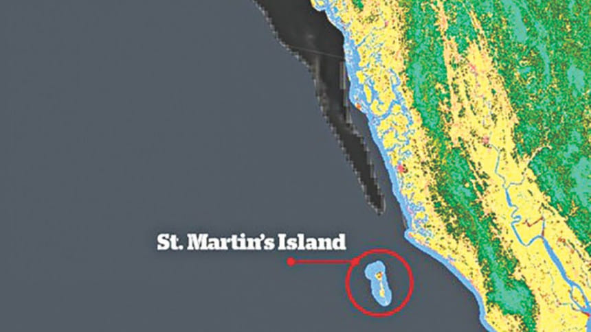
After Myanmar's circulation of a false picture (which claimed to show insurgents training while it was actually a photograph of Bangladeshi freedom fighters during the Liberation War), the Government of Myanmar has yet again come up with another false claim showing Bangladesh's St. Martin's Island as part of its territory. On 6 October 2018, the Government of Myanmar updated its 2015-2018 map of Myanmar Information Management Unit showing St. Martin as a part of their sovereign territory and spread the maps in two global websites (www.dop.gov.mm & www.themimu.info). In the map, similar color has been used for both Myanmar and the Saint Martin's Island. The Bangladesh territories were projected in black. When one looks at the map from the surface level, this false claim is not visible, however, when the map is zoomed in, the difference comes to sight.
Following the event, the Myanmar Ambassador in Dhaka was summoned by the Government of Bangladesh on 6 October 2018. Rear Admiral (retd) M Khurshed Alam, maritime affairs secretary at the Ministry of Foreign Affairs, Government of Bangladesh handed over a strongly worded protest note to him. The Myanmar envoy said it was a “mistake” to show the St. Martin's Island as part of his country's territory. However, we can sense an “ulterior motive” behind drawing and sharing the map of Myanmar on Government approved websites after their dawdle with the repatriation of the displaced Rohingya population.
 For all latest news, follow The Daily Star's Google News channel.
 If anyone looks back at the history since 1937, one can find that the Island had never been a part of Myanmar. St. Martin's Island was part of British-India when Myanmar got separated in 1937. A clear line was drawn that this Island forms part of British India. After the partition of the British India in 1947, it became part of Pakistan and later on a part of independent Bangladesh after the Liberation War of 1971. In 1974, it was clearly stated through a signed agreement between the two states that this Island is part of the territory of Bangladesh. Moreover, even when Bangladesh won the maritime boundary dispute against Myanmar in the International Tribunal for the Law of the Sea (ITLOS) in March 2012, it was clearly mentioned that the Island belong to Bangladesh. The Ministry of Foreign Affairs of Bangladesh is of the view that publication of this map is a deliberate attempt to destroy bilateral relation and regional peace. It has to be noted that there has been no dispute over the ownership of St. Martin till date. The only dispute that Bangladesh had with Myanmar, regarding the delimitation of the maritime boundary, was settled in the ITLOS a few years back.
In the International Courts and Tribunals, parties to boundary and territory disputes often rely on maps favourable to their claims. Traditional international law restricts the evidentiary value of maps so that they provide only collateral, rather than probative evidence of title. In the eye of International Law, maps do not constitute titles. The principle that emerges from international jurisprudence and doctrinal discussions is that cartographic materials do not by themselves have any legal value. Such position of law has been specifically observed whenever the map describes territory of which the authors have had little knowledge, is geographically inaccurate, or is sketched in order to promote a country's claim. Even official maps, that is, those issued or approved by a governmental agency, have been treated with considerable reserve. With regard to maps as such, the popular approach, arising from their inherent limitations, is not to treat them as conclusive, but of relative value. The leading case on this point is Frontier Dispute (Burkina Faso/Republic of Mali). In its 1986 judgment, the International Court of Justice (ICJ) stated that in frontier delimitations “maps merely constitute information” and that “of themselves, and by virtue solely of their existence, they cannot constitute a territorial title.”
This rule is deeply rooted in public international law adjudication and has been confirmed in the context of sovereignty disputes over islands. Max Huber, sole arbitrator in the famous Island of Palma case, already stated in 1928 that 'only with the greatest caution can account be taken of maps in deciding a question of sovereignty'. Under international law a map per se does not constitute a territorial title or legal document to establish territorial rights. For maps in international law, most of the maps are just information.
Subsequent to the strong protest on the part of Bangladesh, Myanmar was bound to remove the information that showed St. Martin as part of its own territory. The Parliamentary Committee of Bangladesh dealing with foreign affairs has asked the ministry to take steps to monitor if such information was published on any other website. After their visible acts of bad faith in the entire Rohingya humanitarian crisis, the mere explanation of 'unintentional mistake' is not credible. The government of Bangladesh has to cautiously face and overcome all the diplomatic acts of Myanmar.
The writer works with Law Desk, The Daily Star.


Comments