
GIS map to show locations of all optical fibre cables
The telecom regulator yesterday launched the country's first web-based interactive GIS map of optical fibre cables, which will help the government and non-government agencies in their future digital planning.
A geographic information system (GIS) is a computer programme for capturing, storing, checking, and displaying data related to positions on Earth's surface. GIS can show many different kinds of data on one map.
 For all latest news, follow The Daily Star's Google News channel.
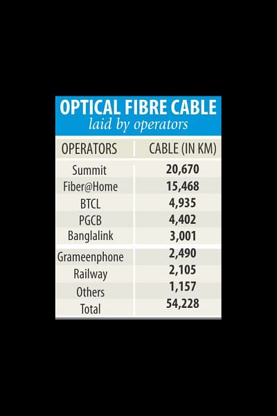
 Around 12 government organisations and private companies already laid 54,228 kilometres of fibre optic cables across the country. The map shows the district-upazila-union level connectivity and the technical aspects of the optical fibre cables.
Shahjahan Mahmood, chairman of Bangladesh Telecommunication Regulatory Commission, launched the GIS map at a press conference at his office.
The map will help boost the government's digitisation programme, he said.
Different companies have laid fibre optic cables haphazardly across the country since 1997, and now there is a map to show the location of all the cables, he added.
He said the map would play an important role in implementing any government or private project related to connectivity.
However, permission would be required to use the map, Mahmood said.
BTRC prepared the GIS map as there is a demand for it in the local market in creating a network.
Under the supervision of BTRC, the Centre for Environmental and Geographical Information Service (CEGIS) of the water resources ministry prepared the map. The CEGIS will also update the map in the next two years.
BTRC officials said 464 upazilas have already been covered by optical fibre cables, while the rest 45 upazilas do not have connectivity. BTRC Vice Chairman Md Ahsan Habib Khan, Commissioner Md Jahurul Haque and senior officials were also present.


Comments